


Using European Space Agency expertise to grow better crops
22/02/2017

When you hear the words European Space Agency (ESA), ambitious missions to mars or spectacular crash-landings on comets may come to mind. What is less likely to occur is agriculture and improving crop yields. But earlier this month (6th-9th February 2017), I attended the 4th ESA Advanced Course on Radar Polarimetry taking place in ESA-ESRIN, Frascati (Italy) for those very reasons.
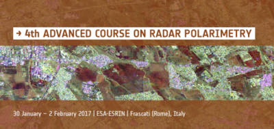 This free course was an excellent opportunity to meet experts in the field of Polarimetric Synthetic Aperture Radar (PolSAR) and to learn more about the potentials and limitations of this technique. PoISAR is a measurement system based on Radar (an antenna on-board a satellite/plane emits an electromagnetic wave down the Earth and records the echo from the land surface) able to record signals at different polarisations…think of it as a camera recording different colours. These polarisations are sensitive to different characteristics (structure, water content, etc.) of the imaged scene.
As a research fellow in Remote Sensing within the Cranfield Soil and Agrifood Institute, I am often involved in research projects looking at detecting crop growth stages, or estimating yield. I was looking forward to learning more about PolSAR, which has many applications in Remote Sensing of vegetation, from measuring tree heights or biomass in the Amazon and the Boreal forests, to detecting objects concealed under vegetation.
Course review
Well, the course went beyond my expectations. It covered the principles of PolSAR, with a focus on advanced measurement techniques like polarimetric interferometry (Pol-InSAR) and polarimetric tomography (Pol-TomoSAR). The morning lectures were very informative, with engaging experts always happy to discuss the numerous questions of the audience (mainly PhD students and Post-Docs). The afternoon practical sessions were well thought out and very useful as teaching PolSAR often relies on a series of mathematical concepts. All this was punctuated by presentations on the latest Earth Observation missions and their scientific results. Beyond the great learning experience, the course was also a good platform for networking with other scientists in universities and in companies involved in SAR Remote Sensing.

The Colosseum, Rome
Frascati is only 30 minutes away from Rome, meaning I had time to make an express visit to the main historical sights (the Colosseum, Pantheon, Trevi Fountain, Vatican), and a typical Italian ice cream of course!
But back to work! The ESA runs various free events within the context of the Scientific Exploitation of Operational Missions program (SEOM). SEOM’s aims include stimulating research, training scientists, and promoting data use and results. In practice, this is done by regularly organising free workshops, short courses, and summer schools on various remote sensing topics covering land, ocean, atmosphere, and cryosphere. And if you miss an event, all the materials are usually made freely available on the ESA-SEOM website. I would definitely recommend this type of courses to any scientists interested in Earth Observation, from MSc students to lecturers.

The lecture room at ESA-ESRIN
Categories & Tags:
Leave a comment on this post:
You might also like…
Finding successful past Cranfield theses
It’s always a good idea to look at examples of theses before you start work on your own. You may find them valuable for reading previous research, and for looking at structure, style and methodology. ...
On‑campus or off‑campus? How Cranfield students found their home away from home
Finding the right place to live is one of the biggest decisions you’ll make as you begin your student journey. Whether you’re looking for the convenience and community of living on-campus or the independence ...

Avoiding common referencing errors
As librarians, we get to see the full spectrum of reference lists in student work —from exemplary to … well, let’s just say, works still very much in progress! We are experts in spotting mistakes ...

Using your Mendeley library after you have left Cranfield
So you have spent the whole year (or more) lovingly collecting references around the topics that matter to you and now you have a large, personalised library in Mendeley Reference Manager containing all that information. ...

Referencing the use of generative AI in your work
We recognise that Artificial Intelligence (AI) has, and will increasingly, become a part of our everyday lives and that we need to adapt to it. Hopefully you will have already seen the guidance for staff ...
Finding part-time work whilst studying at Cranfield – is it right for you?
We know that the cost of living in the UK is a real and ongoing challenge for many students. Whether you are still considering postgraduate study or already preparing for life at university, you ...