


In the tyre tracks of the Edwardian geologists
15/04/2024

In April 1905 a group of amateur geologists loaded their cumbersome bicycles on to a north-bound train at a London rail station and set off for Bedfordshire on a field excursion.
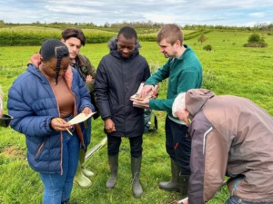
In March 2024 a group of six postgraduate students from Cranfield University undertaking their MSc Group Project ‘Lowland Agricultural Peat Water Discovery Pilot’ – travelled by minibus – and followed part of the same route across the Flit Valley, Bedfordshire to embark on a project aiming to assess the present-day distribution and condition of the fragile peat soil resource in the areas of Flitton and Flitwick Moors. The student team comprised members from MSc courses in Environmental Engineering and Geographical Information Management, now known as Advanced GIS and Remote Sensing, here at Cranfield – the group project is a key part of their year of study.
During a literature review, undertaken as part of the project requested by the Greensand Trust in Bedfordshire, an intriguing academic paper from the Proceedings of the Geologists Association (GA) [1] was unearthed. This paper recorded in sublime detail the activities of the cycling cohort of the Association, providing a glimpse of these enthusiastic geological field explorers who combined the rising public interest in the science of geology with the newfound sense of freedom in cycling, and the expansion of the railway network providing easy access from London. The paper describes in some depth the organisation of these excursions during a period from 1899 to 1910, as recorded in the archives of the GA. It is possible that these trips began before 1899 as early records of the Association were damaged by a fire. The average distance covered on their heavy steel framed cycles is estimated at some 15 miles. Bedfordshire was popular destination for excursions by the GA beginning in 1881, with visits likely on foot to start with, to the chalk outcrops at Totternhoe and continuing until 1915 with an excursion to the Leighton Buzzard sand quarries.
Today, some 125 years later, the Cranfield MSc students followed footpaths along the River Flit exploring the present-day land use and visiting a nature reserve at Flitton Moor. Sadly there is no visual record of the cycling geologists themselves, but the importance of the peatlands to the local communities is captured in the earlier painting by Thomas Fisher (c.1815) entitled ‘Flitton Moor’ [2], showing peat cutters working in the Flit Valley, shown here. Today, there are both historic peat records from this area, and accurate (if sparse) observations made by the soil surveyors in the 1950s. These field sheet maps are part of the unique records of the Soil Survey of England and Wales and are archived at Cranfield University [3].
The student project is a small part of the national programme launched by the Environment Agency across England to collect an enhance the record to the remaining lowland peat resource, with a view to protecting this as contribution to carbon storage [4]. Much of the project area is already protected by designations such as a Site of Special Scientific Interest (SSSI) or by being a designated Local Nature Reserve (LNR). The challenge is to map out the future management of these sites as a contribution to the aspiration of attaining net zero in the coming decades.
References: [1] Thomas Hose, Proceedings of the Geologists Association, 2018, Awheel in Edwardian Bedfordshire: A 1905 Geologists’ Association cycling excursion revisited and contextualised.[2] Thomas Fisher (c.1815) ‘Flitton Moor’.[3] The archive of Soil Survey of England and Wales is assessable through the LandIS digital portal (http://www.landis.org.uk).[4] Lowland Agricultural Peat Water Pilot Discovery Pilot. Funded in England by the Environment Agency.

Categories & Tags:
Leave a comment on this post:
You might also like…

Using AI tools for your literature review
There are a proliferation of AI tools that can help you organise your life, work and study. This post focuses on academic or scholarly tools that have been developed to enhance the literature searching process, whether for independent research, an assignment or thesis. Bear in mind that these predominantly relate to finding journal/research papers, and not technical, business or trade sources such as standards, market research, industry reports or financial data. So ...

Finding successful past Cranfield theses
It’s always a good idea to look at examples of theses before you start work on your own. You may find them valuable for reading previous research, and for looking at structure, style and methodology. ...
On‑campus or off‑campus? How Cranfield students found their home away from home
Finding the right place to live is one of the biggest decisions you’ll make as you begin your student journey. Whether you’re looking for the convenience and community of living on-campus or the independence ...

Avoiding common referencing errors
As librarians, we get to see the full spectrum of reference lists in student work —from exemplary to … well, let’s just say, works still very much in progress! We are experts in spotting mistakes ...

Using your Mendeley library after you have left Cranfield
So you have spent the whole year (or more) lovingly collecting references around the topics that matter to you and now you have a large, personalised library in Mendeley Reference Manager containing all that information. ...

Referencing the use of generative AI in your work
We recognise that Artificial Intelligence (AI) has, and will increasingly, become a part of our everyday lives and that we need to adapt to it. Hopefully you will have already seen the guidance for staff ...
Comments are closed.