


Flooding in the Aire: why we can reduce floods in the UK
19/01/2016

As a researcher looking at sediment transport and storage in the Leeds Flood Alleviation Scheme, I need rain. Rain causes surface runoff and runoff causes erosion, which eventually results in sediment transported towards and within the river. When I began my work, everyone told me that the rain would be the least of my problems: “It’s always raining in Leeds”, they said. However, this hasn’t been the case in Leeds during the past year. It was hard to imagine how vulnerable Leeds actually is to flooding.
Then, November brought several storm events causing the river levels to rise close to flooding. Gradually the soil became more and more saturated over the course of the wet month of December until storm Eva hit Yorkshire at Christmas. On the morning of the 26th of December this eventually caused the River Aire in Leeds to quickly rise to its highest level ever recorded (almost 3m at Crown Point), and resulted in the flooding of major parts of the city. (The highest level before that was 2.5m in 2007, when the city narrowly escaped flooding).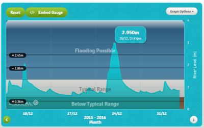
Flooding happens in many parts of the world. My home street in Belgium has flooded several times. I’ve seen the impact of flooding along the Jamuna River in Bangladesh, and now the Aire has flooded in Leeds. But there is a big difference in how we perceive these flood risks. In Bangladesh, for many people floods are a fact of life. They know that living along the banks of the Jamuna means that one day you will likely have to move because of flooding. It’s just too big to stop. Here on the contrary, our rivers are not that big, so we get the idea that we are able to stop it. If that doesn’t happen, we get angry with the river that has ’caused’ this and angry with the government and their agencies for not preventing the disaster.
But can we actually stop such a huge amount of water? Well, partially we can. Or at least, we can manage it better than we do now. We are part of the problem. By building houses around our rivers, consolidating their banks and separating them from the floodplains, we’ve taken the space the river needs to flow. With increasing urbanisation and agriculture, we have sealed soils and thereby prevented infiltration of water in the soil. There is more surface water and less space for it to flow, resulting in a higher flood risk. So if we have partially caused the problem, we can do something about it. We can not only build flood walls, but we can also (re)create more space for the water to flow, slow down the water and increase infiltration to reduce surface flow.
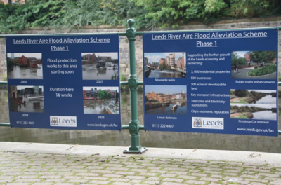
That’s where flood risk management and flood alleviation strategies come in. In Leeds, construction started last year on a Flood Alleviation Scheme (FAS) that will reduce flood risk within the heart of the city. It includes the installation of movable weirs and other measure which improve flood conveyance. These measures are designed to reduce the levels of flood flows (i.e. creating more space for the water), thereby reducing the need for high flood walls. But unfortunately these measures are still under construction and the storm came too early…
So what is the link between sediment and flood alleviation? Well, in many cases, hard engineering is not the entire solution. Whilst the current scheme in Leeds is the best management compromise, the solution increases the likelihood of sediment which will have ecological impacts and maintenance implications (such as the need for dredging). My project is developing new evidence on sediment transport and storage in Leeds to inform future maintenance operations which can ensure long-term flood protection. It is also developing a quick, reliable ‘sediment fingerprinting’ method to identify where sediment is coming from upland. This knowledge will help us to move towards catchment-based flood risk management by creating opportunities to tackle soil erosion in a targeted way and reduce the amount of sediment coming into the river.
My wish for Leeds in the coming year is just enough rain to get some good sediment samples, but not that much to cause actual flooding!
Find out more about fluvial geomorphology research at Cranfield University.
Categories & Tags:
Leave a comment on this post:
You might also like…

Referencing the use of generative AI in your work
We recognise that Artificial Intelligence (AI) has, and will increasingly, become a part of our everyday lives and that we need to adapt to it. Hopefully you will have already seen the guidance for staff ...
Finding part-time work whilst studying at Cranfield – is it right for you?
We know that the cost of living in the UK is a real and ongoing challenge for many students. Whether you are still considering postgraduate study or already preparing for life at university, you ...

Leaving Cranfield soon? Have you heard about Alumni Library Online?
We are proud to offer one of the UK’s leading university library services for alumni. Alumni Library Online gives you instant access to thousands of top quality journal articles and the latest thinking to support ...

Want to know more about research methods?
Research methods are the strategies and tools used to gather, analyse and interpret data or evidence to uncover new information or create better understanding of a topic. Research methodology is the theory, justification and assumptions ...

Come for Cranfield, stay for Milton Keynes: how Bucks, Beds and the OxCam region are just getting started
Heard the one about the entry-level job that needed three years of experience? Sadly we all have, and that’s why in a jobs market where practical, hands-on experience is so important, study where collaboration ...

British Standards and ISO standards demystified
We are frequently asked how to find ISO (International Standards Organisation) standards. The best way to find them is to go straight to our British Standards Online (BSOL) service. Why go to British Standards if you ...