


Drones in the Cumbria skies: the floods of Christmas
08/01/2016

Christmas 2015 will not be remembered as a white Christmas, but as a wet one. The media was full of images of the homes ruined by floods, particularly in Cumbria, as a result of winter storms and heavy rainfall. As an expert in flood risk management, I visited Cockermouth, one of the worst affected areas, to see the damage for myself.
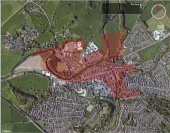
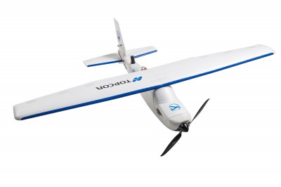 I conducted a survey with drones or ‘unmanned aerial vehicles’ which allowed me and my team to identify with high accuracy the flood extent and damage.
The areas we visited were completely devastated in the aftermath of the floods. Many people lost the contents of their homes. The emergency services, including firemen, the police and the army, were on site to provide support and aid to the local people. Roads had debris scattered all along them for miles, and some bridges had totally or partially collapsed. Soil movement had exposed pipes and drainage systems to the elements. In the midst of this, the local residents were laboriously cleaning their homes, unaware that storms Eva and Frank were on the horizon and they would be at risk again.
Within the difficult context of severe flooding, drones have the potential to help researchers to map with very high accuracy the extent and damage of the flood event. Unlike other options (such as satellite imaging) they can be rapidly, inexpensively, and flexibly deployed. Their ability to scout areas reduces distortion caused by building shadows or atmospheric conditions like cloud or pollution. Their immediacy can also help to deploy emergency resources where and when they are most needed, helping isolated communities or directing efforts to protect properties or infrastructure.
 Taking to the skies in Cockermouth was part of a new research project funded by NERC which brings together commercial flood modelling and risk specialists Ambiental Ltd with academic expertise from Cranfield University as well as colleagues from the University of Leicester, Loughborough University and Imperial College London.
UAV imagery was collected in collaboration with Caintech Ltd (following Civil Aviation Authority legislation at all times.) This is the first time CAA has given permission to carry out survey works over any congested space in the UK with a range of 1000m from the pilot and up to a potential altitude of 400ft AGL. From a research point of view, this was an unprecedented opportunity to apply our ideas to a real world situation.
The principal aim of the new ‘Dronewatch’ project is to advance flood extent mapping, and to refine current insurance industry practice in evidence based flood damage assessment. We are hoping to prove the feasibility of a novel approach which integrates satellite data with UAV data for urban flood extent mapping and damage assessment. We will also be providing definitions of the service offer required by the end user for the rapid and accurate mapping of flood extent and damage assessment in urban areas.
While the flooding in the UK has focussed our attentions on our changing climate and resilience to environmental disaster, the implications are international. With reports that El Nino will make flooding more common, and the impacts on some of the most vulnerable communities of our world likely to be great, drones could help with emergency responses and flood risk management planning in both the short and long term.
If you’d like to find out more about the use of new technologies for environmental management, you might be interested in my two week UAVs for Environmental Monitoring course, or the Cranfield MSc in Environmental Risk Management.
![]()
UPDATE – August 2016 – this project has been shortlisted for the O2 NextGen Award
Media coverage of this project
Public Finance http://www.publicfinance.co.uk/opinion/2016/02/floods-demonstrate-value-eyes-sky
Civil Service World http://www.civilserviceworld.com/articles/opinion/drones-arent-just-threat-above-–-they-have-public-service-possibilities-too
InsuranceAge http://www.insuranceage.co.uk/insurance-age/opinion/2453285/how-drones-can-support-insurance
Public Technology https://www.publictechnology.net/articles/opinion/drones-can-offer-public-sector-treasure-trove-data-we-cant-just-view-them-threat
Categories & Tags:
Leave a comment on this post:
You might also like…

Avoiding common referencing errors
As librarians, we get to see the full spectrum of reference lists in student work —from exemplary to … well, let’s just say, works still very much in progress! We are experts in spotting mistakes ...

Using your Mendeley library after you have left Cranfield
So you have spent the whole year (or more) lovingly collecting references around the topics that matter to you and now you have a large, personalised library in Mendeley Reference Manager containing all that information. ...

Referencing the use of generative AI in your work
We recognise that Artificial Intelligence (AI) has, and will increasingly, become a part of our everyday lives and that we need to adapt to it. Hopefully you will have already seen the guidance for staff ...
Finding part-time work whilst studying at Cranfield – is it right for you?
We know that the cost of living in the UK is a real and ongoing challenge for many students. Whether you are still considering postgraduate study or already preparing for life at university, you ...

Leaving Cranfield soon? Have you heard about Alumni Library Online?
We are proud to offer one of the UK’s leading university library services for alumni. Alumni Library Online gives you instant access to thousands of top quality journal articles and the latest thinking to support ...

Want to know more about research methods?
Research methods are the strategies and tools used to gather, analyse and interpret data or evidence to uncover new information or create better understanding of a topic. Research methodology is the theory, justification and assumptions ...